Tuesday, May 16, 2017
Other Blog
Forgive me for my tardiness, but there has been a problem. I have not been able to blog on here, so when I can not use this, I will be using my other blog. I will be blogging today hopefully on our most recent hike.
Sunday, November 20, 2016
Murray hill (west flank)
Hiking Date: November 19, 2016
Location: Palm Springs, CA
Difficulty: hard
Distance: 7 miles (out and back)
Goal: To hike up to Murray hill and back in 12 hours
Goal completed: yes
At the start of Thanksgiving break, we headed out to the desert at 6:30am and hiked the loved, Murray Hill.
 |
| Murray Hill from the east hike |
My mom and my papa LOVE this hike. Not only was it in the desert, our favorite hiking place, but it was only 5 hours! We started on the west side of the mountain. The hike was easy to get to because it was in a neighborhood.

From the car, we hiked over to the side of the mountain and reached a junction with the Henderson trail. We then switch backed up the side of the mountain and came to the top, where Murray hill was visible. I was bolting ahead of the others!

We then ascended up to a point at 1797' feet we call "Murray Jr. " We rested there and ate some stuff, like Ritz with peanut butter, candy bars, Cliff bars, pretzels, and beef jerky.


This video was cut short, but here it is anyway. Sorry if it is blurry.
From there, we hiked down and climbed up and onto the canyon walls. We found these round objects and had a debate to see if they were berries or poop.
 |
| If it is berries, they would be very dry. |
We got to the top of the canyon and made the final trek up the face of the mountain, and were there!!!
 |
| Our third time on Murray hill |

We got down into the car, and headed into Palm Desert, where we met my dad and sister at Costco for lunch.
 |
| Perfect ending to the hike |
That is it for today, bye!
Saturday, September 24, 2016
Mt Baldy Loop
Hiking Date: September 24, 2016
Location: San Gabriel Wilderness, CA
Difficulty: Hard
Distance: 11.3 miles (loop)
Hours hiked: 6
Goal: To hike the entire Mt. Baldy loop in 12 hours
Goal completed: Yes
Mt. Baldy loop is a well known hiking trail for those seeking a challenge. The hike is not that hard and you also reach one of the highest summits in Southern California. Although it is a ways away from the nearest urban city, Upland, at the end of the hike, you will think it was worth it.
As we were driving up the mountain, we looked at the packed Icehouse Canyon parking lot. But as we parked at our hike parking lot, I think this broke the record...

From there, we hiked up the half mile road to San Anotinio Falls

But then we heard a siren.
At first we thought it was going somewhere else, so we went on. But then we heard the siren again, only it seemed to be getting louder. In fact, an ambulance was hurtling toward us! We moved out of the way, and it rushed up the service road. When we came walking up the service road, we saw a big group of people crowded over a man.
He had a heart attack.
The medics were performing CPR on the man and he had a mouth mask over his mouth and nose (like the kind they use on you when you are having a major surgery). It was scary. So for those of you that pray, please pray for this man.
Back to the hike, we cut off the the service road and hiked up and onto one of the faces of the "Baldy Bowl".
 |
| The Baldy Bowl |
The hike was a lot like Vivian, Here is a typical view of the hike
After reaching the Sierra Club Ski Hut in 2 miles, we started to climb out of the canyon. At this point, we were very close to the Baldy Bowl.

From there, we crossed over and switch backed up through some pine trees. I was going pretty fast. In fact, I left mom and Papa behind and passed a couple forest rangers! After reaching the top of the ridge, we crossed over again at the top of Baldy Bowl and climbed another 30 min. and we reached the summit!!

After the summit, we headed down the south side of the mountain, made our way onto the east arm of Mt. Baldy, and started descending Devil's Backbone.

If you want to hike this part of the trail, first, see this.
When we got to The Top Of Notch restaurant, we got to go down the nice chairlift
OK, I need a break of typing, see you later, logging off.
Sunday, September 11, 2016
Hiking update
It has been a while since I have done a post.
To fix that, I am going to give an update on the stuff that is going on in the Hardhikers club.
*Our hikes have been limited due to my moms new fill time school psychology job at the School District.
*Papa has been going on a hike a week probably because he is always behind us on our hikes.

*Because of Papa hiking, I asked if I can go on a few of the hikes with him (on Friday afternoon)
That is all I wanted to share. In a couple weeks, we are going to hike Mt. Baldy (All three of us). Good bye!

*Because of Papa hiking, I asked if I can go on a few of the hikes with him (on Friday afternoon)
That is all I wanted to share. In a couple weeks, we are going to hike Mt. Baldy (All three of us). Good bye!
Friday, July 22, 2016
Vivian Creek to San Gorgonio Summit
Hiking date: July 21, 2016
Location: San Gorgonio wilderness, CA
Difficultly: Hard
Distance: 17.8 miles
Hours hiked: 12
Goal: To reach San Gorgonio mountain
via Vivian Creek in one day
Goal completed: Yes
This hike was the longest and biggest hike that I have ever done in my entire life. Also, I hiked at a higher altitude than I have ever been at. What more? We also completed our biggest summit ever, the biggest one in southern California. Here is a list of summits we have hiked:
Pisca Peak (via Wildwood) 3000'
Zanja Peak (via Crafton Hills) 3000'
Murray Hill (via Clara Burgess and Wild Horse trails) 2000'
San Gorgonio Mountain (via Vivian Creek) 11,000'
I rounded the heights to the closest thousand and saw that San Gorgonio mountain was still the highest in Southern California. Murray Hill, Pisca Peak, and all the other small peaks are just tall peaks of their little ranges. San Gorgonio, on the other hand, towers above San Jacinto peak, Mt. Baldy, Torro Peak, and everything else in southern California.
For this hike, we had to leave at about 5:00am. We left the house and drove to the Mill Creek Ranger Station and got in the car with Papa. We drove up to Forest Falls and were on the trail at about 6:00am. We started hiking up the road leading to the riverbed, beginning our long journey. Before we got to the summit, we had to hike 8.9 miles of trail, passing 3 camps, Vivian Camp at 1.2 miles, Halfway camp at 2.1 miles. and High camp at 4.8 miles.

10 minutes later, we crossed the empty riverbed.
 |
| Crossing the riverbed, we had to be careful of flash floods ;) |
Then we started one of the hardest parts of the trail, a whole mile of switchbacks.

Soon after, the trail leveled out at the mile marker.
 |
| A resting log next to the mile marker. |

After the mile marker, we went through a beautiful forest of conifer pines, bushes, and more. A little ways before Halfway Camp we went through some beautiful bushes.


When we got to Halfway Camp, it wasn't even 8:15 yet, we were booking it!
 |
| The junction leading to Halfway camp and the trail leading to High Camp. For our snacks, we love Ritz with peanut butter. It's become our go to snack. |
From Halfway camp, we hiked up two sets of switchbacks, rounded a bend, and hiked down to High Camp.

Beyond High Camp it was another three hours until we would get to the summit, and it would be hard. For a lot of the time, we would be above 10,000', which was in the zone where you could get altitude sickness. But we would get good views of the San Jacinto mountains and the Yucaipa Ridge down below. We stopped at High Creek to soak a stiff towel in the water. It was passed around our necks to cool us

After High Camp, we hiked up several switchbacks to lookout point where the San Jacinto mountains and the desert came into the view

After that, we started crossing a C shape across the ridge. It was hard!


Then, we came out of the bend and we saw the summit about five minutes away. So slowly, we climbed on top of the summit. We were rewarded with views, cell reception, ham sandwiches, and the sense of satisfaction of being at the top of everything in Southern California. The summit was windy and cold. The big thing was chipmunks, they were EVERYWHERE on the summit, crawling around and eating Pita chips Papa threw on the ground for them. They were cool to have around. We could see for miles, the Mohave desert, Big Bear Lake, and more. But we were only halfway, because we had to go down!!
 |
| San Goronigo Mountain |
Friday, July 8, 2016
Gear update
Over the past 1 1/2 years, we have improved a LOT on gear.
Here is a picture that was token back in February, 2015. We were hiking Cactus to Clouds for the second time and Papa hadn't even joined the Hardhikers club yet. In fact, we hadn't even really started our hiking routine yet. I had no Camelbak, no altimeter, no first aid kit, no whistle, no anything.

This photo was taken back in July, 2015. I had my Camelbak, a cheap altimeter, a hiking hat, and good hiking shoes.

Here I am on the Vivian Creek trail (to Halfway Camp), back in April, 2016. I had all the gear I currently have now

Just recently, we have taken a huge Milestone in hiking. We are getting new hiking backpacks!!! My grandparents got it for me for my birthday.
Here is the size of a backpack I have currently:
Here is the backpack I am going to get:
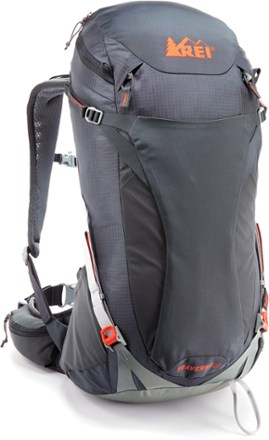
When I post my next post, I will be wearing the backpack. see you then!
Monday, July 4, 2016
Two days in the Yosemite National Park
You are probably wondering why we went two days to Yosemite National Park. On one of the days we were on vacation we were wondering what to do (we stayed at Bass Lake for four nights). So why not go again! People come from all over the world to just look here once. We got to go two times in three days since it was only an hour and a half away from us!!!
We hiked two hikes that were both waterfall hikes, here they are:
1. Lower Yosemite Fall
Hiking date: July 25, 2016
Location: Yosemite Valley, CA
Difficulty: easy
Distance: one mile
Minutes hiked: 30 minutes
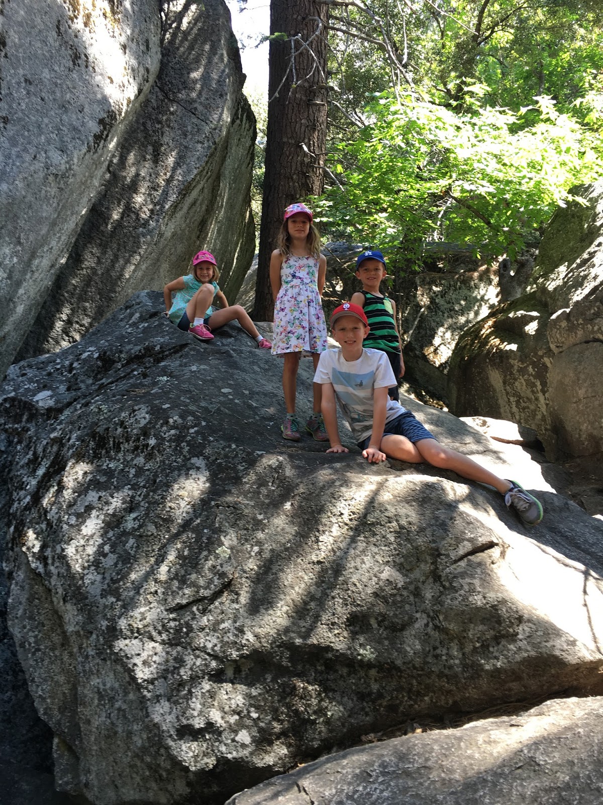
When we entered Yosemite, we could see a lot . Here is the stats of the trip.
 |
| Olivia age 3, Daniel age 6, Mia age 8, me age 9, and Kendall age 7. (left to right) |
 |
| Aua, Jeremy Elkins and mom and dad |

It was crowded when we got there, which proves it is just an easy walk. But it was the biggest waterfall in the U.S, so were ready for that. We also went exploring through a bunch of rocks.
3 minutes later, we got to the waterfall. We saw people climbing up close to the waterfall. so we left the crowds behind and climbed. Only when we got back did we realize that we weren't allowed to climb around.
 |
| Almost there! |

Then we started the 8 minute trek down the road.

Here is a quick video so you can see what the walk is like. It wiped us out!
Hike two: Bridalveil Fall
Hiking date: July 27, 2016
Location: Yosemite Valley, CA
Difficulty: easy
Distance: 0.5 easy way, 4.2 longer way
Minutes hiked: 30 minutes easy way, 45 longer way
Bridalveil Fall is a lot like Yosemite Fall, only shorter
Bridalveil Fall is a lot like Yosemite Fall, only shorter
 |
| Bridalveil Fall |

Daniel wanted to hike to the "El Capitan Bridge"

 |
| El Capitan |
At one point, we left the main attraction and moved on to a real trail. Since Daniel really wanted to hike the bridge, we split up. The girls left, leaving Daniel, Mr. Jeremy, my dad, and obviously me. We didn't run into anything for a long time until we reached a junction that led to different places like campgrounds and Half Dome. When we got back, we were rewarded with a cool car and the Merced river to swim in.

The week was a sucuss! Aside with being carsick while driving, the trip, I say, was a 10!
Subscribe to:
Posts (Atom)